Map Shows Which US Regions Face the Highest Risk of Major Power Blackouts
Electricity failure in the United States is no longer an abstract possibility. New outage mapping tools are transforming grid vulnerability into something spatial, measurable, and deeply regional. County by county, researchers are identifying where extreme weather is most likely to trigger cascading, multi day blackouts.
These maps draw on decades of outage records, climate exposure data, and infrastructure age, revealing patterns that are not evenly distributed. Risk clusters around coastlines, energy intensive regions, and fast growing urban centers where demand is accelerating faster than grid upgrades.
What emerges is a portrait of a power system stretched thin. Reliability is no longer dictated only by national capacity, but by local weaknesses that can turn a single storm into a prolonged blackout.
The Anatomy of the Blackout Map: Data, Models, and Hidden Hot Spots

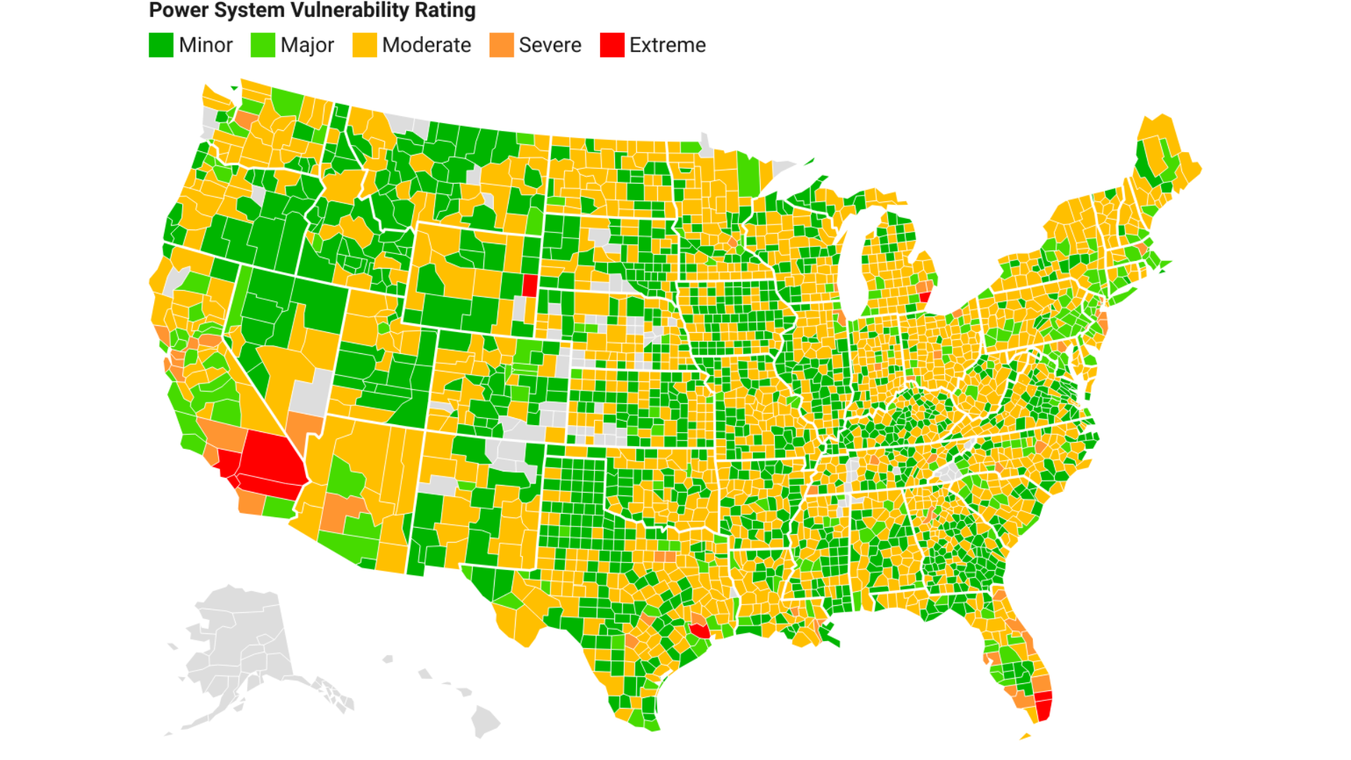
The most comprehensive blackout vulnerability assessments come from machine learning driven research conducted by institutions such as Texas A and M University. By analyzing outage frequency, duration, and intensity, researchers have identified hundreds of counties that experience power loss more often and for longer periods than previously acknowledged.
These studies integrate infrastructure age, climate trends, and load growth, producing what researchers describe as power system vulnerability maps. The findings reveal more than isolated failures. They expose systemic fragility embedded in regional grids.
Importantly, these academic models align closely with warnings issued by grid regulators. Seasonal reliability assessments increasingly echo what the data shows: certain regions are entering extreme weather seasons with little margin for error.
Coasts and Corridors: Where Weather and Infrastructure Collide

Coastal regions emerge as consistent high risk zones. Along the West Coast, hydropower dependence, wildfire exposure, and fuel constraints make states like California and Washington particularly vulnerable during both winter cold snaps and summer heat waves.
The Gulf Coast and Atlantic seaboard face a different but equally dangerous mix. Hurricanes, flooding, and salt exposed infrastructure strain systems that were often built decades ago for milder conditions. Dense population corridors in the Northeast further amplify outage impacts when failures occur.
In these regions, extreme weather does not need to be unprecedented to be catastrophic. It only needs to arrive faster than aging infrastructure can respond.
Texas, Heat, and the Future of Cascading Blackouts

If the blackout map has a focal point, it is Texas. Rapid population growth, energy intensive data centers, and thin reserve margins have turned the state into a case study in modern grid stress. Winter storms and summer heat domes now pose equally serious threats.
The lessons of recent grid failures are shaping national concern. Regulators warn that regions stressed in winter are often the same ones that struggle during summer peaks. Ice storms, heat waves, and fuel supply disruptions increasingly overlap in their impact.
Taken together, the new maps suggest a sobering conclusion. The risk of catastrophic blackouts is no longer hypothetical. It is already embedded in specific places, waiting for the next extreme season to expose the limits of an overextended grid.